
Watch the Tersus MVP S2 SLAM backpack system in action and explore the rich datasets it captures.
Work Hard, Play Hard. Why Not Both?
Over the past 20 years, my career has been deeply rooted in location technology, and solving complex problems with some of the most advanced tools in the geospatial industry. Much of this has been on the bleeding edge of innovation, far beyond what the public sees as consumers or users of the data. It’s exciting, often very challenging, and as anyone in the geospatial world knows, it’s not easy to explain to anyone outside the industry what it’s really all about.
Because of this, I often need to find time to recharge, and disconnect from the hum of it all.
For those who know me well, I have three strong passions at my core that include chasing adventure in the outdoors, immersing myself in live and recorded music, and diving deep into the world of technology in every direction.
I spend much of my spare time exploring the arid Western United States mountain biking everywhere from rugged chunky and rocky desert trails to smooth rolling forested singletrack through the mountains, hiking and rock climbing high-desert landscapes, and wandering on skis through tree-covered glades (when there’s snow to be found). That connection to wide open spaces has always been what’s grounded me.
Somewhere in the middle of all that adventure, you’ll often find me attending outdoor music festivals each year, gathered with hundreds to thousands of others who’ve traveled to the same natural landscape for a shared purpose, the music! There’s something powerful about the connection of everyone there embracing the energy and excitement of live music across an open landscape, or when it’s reflecting off those giant natural red sandstone rock walls.
Lastly, there’s the third piece of the puzzle, technology. I’m a self-admitted technology driven gear junkie. It’s an addiction that’s been there since I was a young child. As an adult, I’m the kind of person who probably has the right tool in the truck, or in my backpack on a long hike when someone needs it the most. It’s a blessing for the unprepared but also occasionally a running joke among many of my close friends and family. However, to me the right gear isn’t just equipment, it’s about the possibility of adventure to safely go further, experiences to be captured and shared among friends, and ideas to come to life.
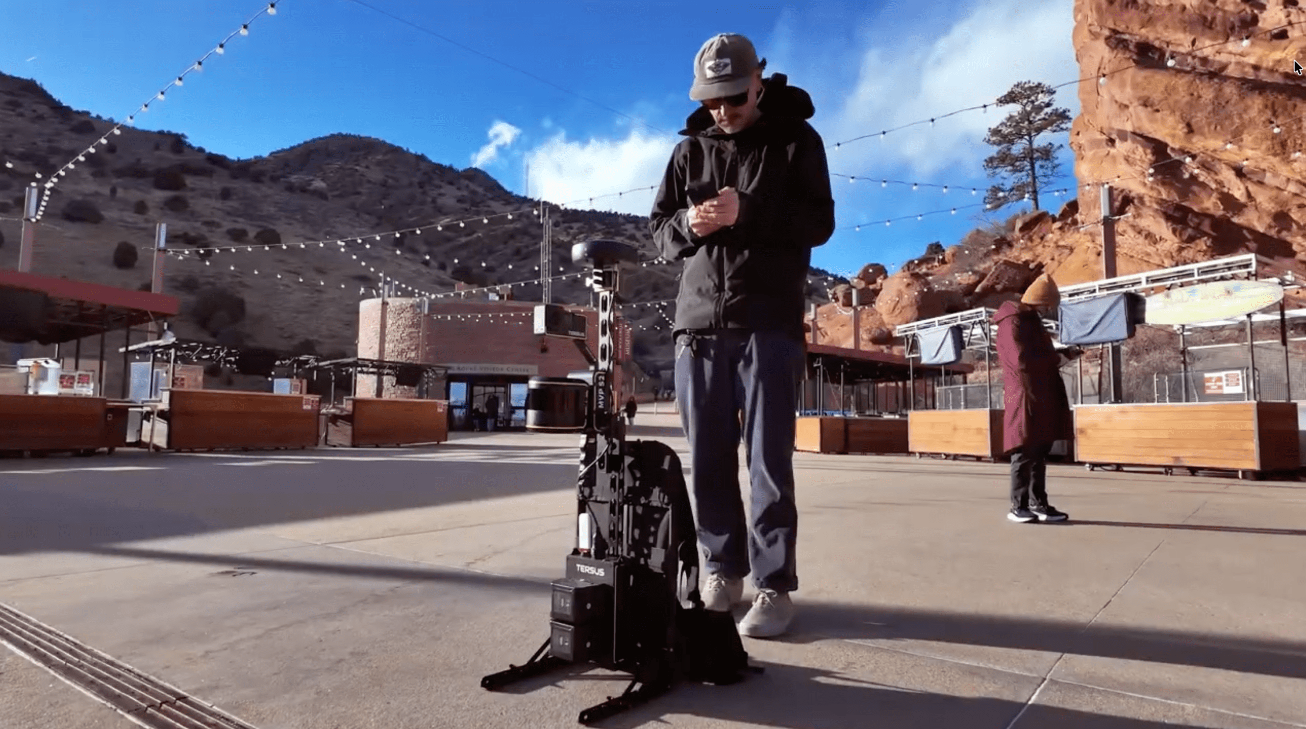
While in Denver, Colorado for Geo Week 2026, I had the opportunity to experience exactly that, and to share it with a friend, colleague and music lover, Peter Yang from Tersus GNSS. Peter hadn’t spent much time in the mountains, or at elevation for that matter, so this was a fun treat! Together, we visited Red Rocks Amphitheater, a place that has embodied the love of music and nature since its opening in 1941. Sharing the natural landscape with the greats like Jimmy Hendrix, Bob Dylan, WideSpread Panic, and even local longtime Boulder based jam acts like Left Over Salmon.
Paint The Landscape And Share The Experience
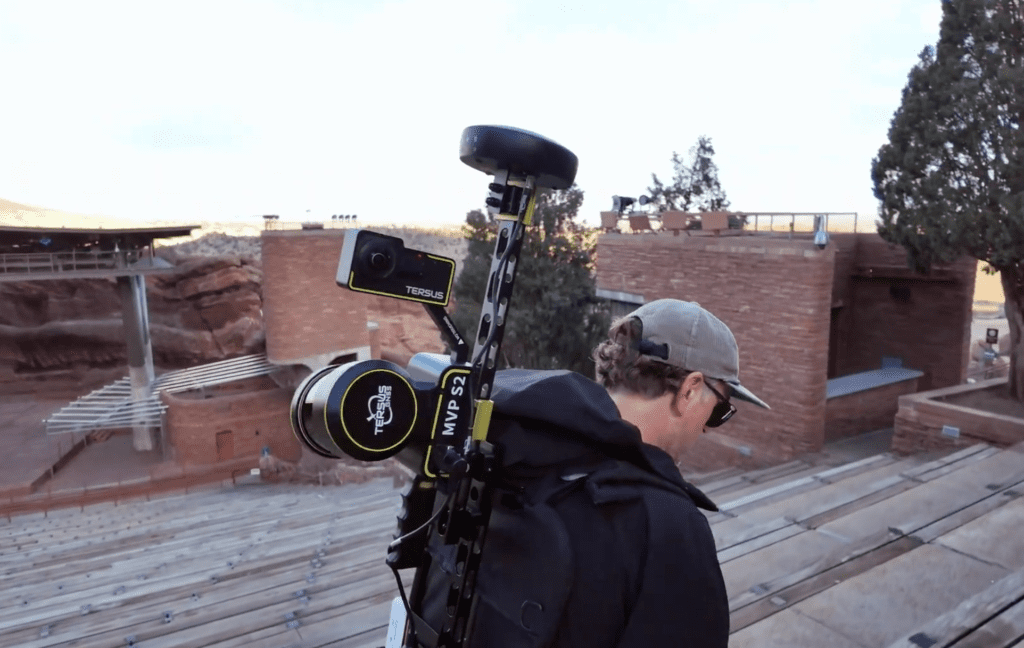
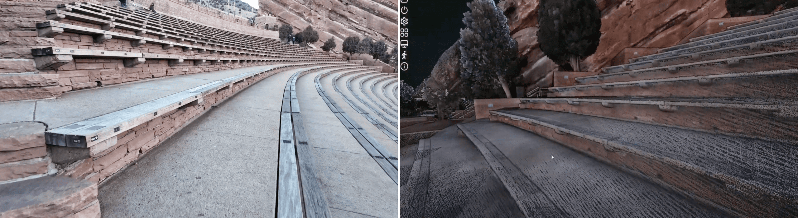
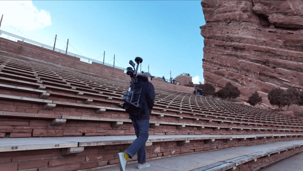
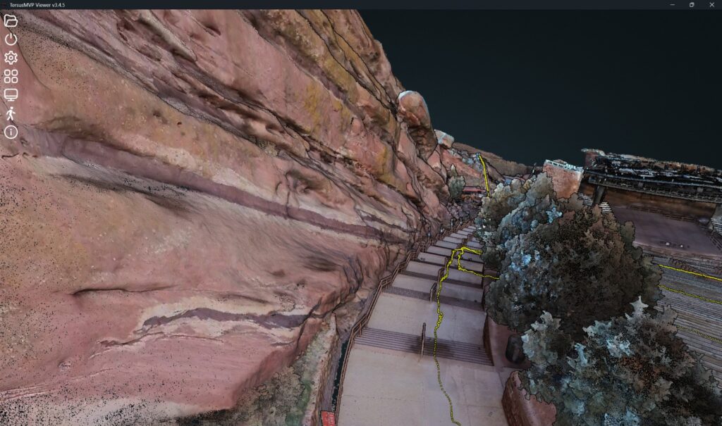
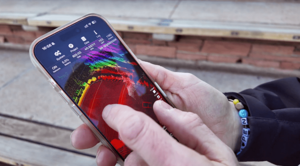
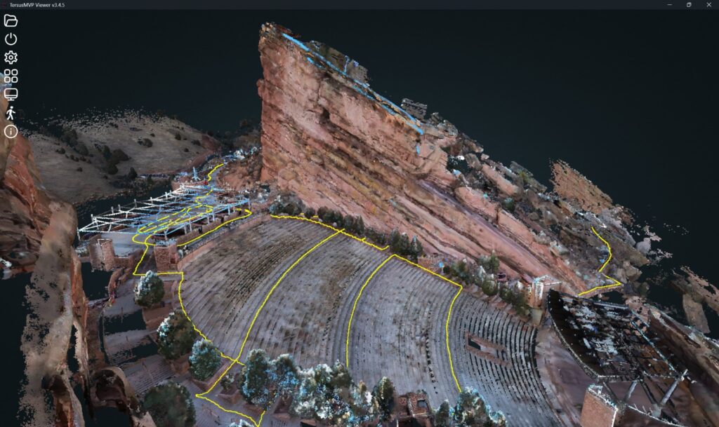
Naturally being the spatial technology evangelists Peter and I are, we decided to capture this iconic place with the Tersus MVP S2. Red Rocks isn’t a simple environment and we wanted to see how it captured its unique construction of repeating rows of seating and how it collected the depth and texture of the red sandstone monoliths. The Tersus MVP S2 is a system that consists of a camera, LiDAR sensor, GNSS positioning technology and some pretty robust SLAM algorithms to tie it all together to create a colorized 3D point cloud with all points spatially located to CM level precision of each other. As we walk, it figures out where it is while simultaneously building a map. The LiDAR collects millions of points, the camera adds color, and the positioning engine keeps everything spatially aligned to create a colorized 3D point cloud with each point located to centimeter-level precision relative to the others.
This capture includes roughly 20 minutes of walking the area to create this beautiful colorized 3D point cloud of Red Rocks Amphitheater. We then processed the data which took about an hour on a 32 GB laptop. The point cloud turned out very clean with hard edges, innocent bystanders walking by were automatically removed and the rock texture turned out with fantastic detail!
Catch My Drift
One of the long-standing challenges with SLAM technology is drift. A system can start out localizing and mapping its location very accurately, but can experience drift over time. Drift happens for a few reasons. Sometimes the system struggles to recognize and re-tie features as you move through an environment, or sometimes its inherent sensor noise (think fuzzy edges or floating parasite data) causes issues. Worse yet a weak SLAM engine that can’t properly balance all the incoming data. They are complex systems, and if one component is weak, it can be seen in the results.
The data can still appear great on a screen, even very clean and detailed, and mind blowing to look at. If too much error feeds into the math from the hardware, or if the algorithm isn’t precise enough, the solution can slowly become unreliable. For visualization, that might be fine. However, for surveying or engineering, where accurate spatial representation and precise 3D measurements matter, it’s not.
Best practices apply with any SLAM capture system to reduce things like odometry error, where the system is trying to estimate how much happens between two moments in time. This can be a challenge as erroneous data can compound over time and build upon itself with each motion estimate, as they all include some small level of uncertainty. In practice, each successive estimate builds on the previous one, allowing uncertainty to propagate forward as data continues to be collected.
How Does Tersus’s MVP S2 Work To Reduce Drift?
Older SLAM systems, and even some newer ones without advanced processing, are great in concept but may lack the sophistication to minimize those compounding errors. The old adage of good data in, good data out applies more so than ever. Because of this, high-end systems like the MVP S2 start with a balanced, high-quality sensor stack, fused with advanced processing that take SLAM technology to another level.
The MVP S2 combines a strong hardware foundation with an advanced processing engine.
Camera:
Capturing images on the device is an Insta360 unit with dual 1-inch sensors and Leica glass that provides solid low-light performance. This mattered for us as we were working late in the day and chasing the sun dropping behind the mountain top as we walked around the amphitheater.
LiDAR
The system incorporates a Hesai XT32 sensor. The unit has 32 channels for better density, and helps to provide stronger structural definition at distance. This aided in capturing the rock formations from a distance, and keep structure in the SLAM algorithm as we turned corners, and moved about the site.
Real-time GNSS
The Tersus MVP S2 includes a centimeter-level GNSS receiver that ties the point cloud to real-world coordinates. It supports NTRIP real-time corrections, but for remote locations without cellular coverage or GNSS networks, it can also be paired with a Tersus Luka GNSS receiver. This setup opens the ability to leverage both TAP PPP-based corrections and a base/rover configuration over UHF radio, making it fully capable of working anywhere, even off the grid.The Tersus Mapper Software fully supports coordinate transformations, and Ground Control Points (GCP) into the project. The GNSS is tightly coupled with the SLAM algorithm, so when you adjust GCPs, it recalculates the overall solution rather than simply shifting the entire dataset.
Proprietary SLAM Algorithm
This is where the MVP S2 pulls ahead from the pack as it has a proprietary SLAM algorithm designed by Tersus’s in-house team of wizards.
Things like optimization stability is a big one. Open source SLAM implementations often are not heavily tuned for very long trajectories or large datasets. Over time, maintaining consistency can become challenging. As shown in the data, the MVP S2 avoids this issue by leveraging the LiDAR sensor’s long‑range measurements to tie structures together, keeping the map accurate and stable from start to finish.
Tighter GNSS integration is another difference. Some systems fuse GNSS as only a basic function, or for localization only. The MVP S2 includes tighter coupling, and intelligent blending between GNSS and LiDAR depending on signal quality to aid outdoors with drift.
Tersus’s MVP Mapper software has moving objects and reflective surface filtering built into its automated processing. This helps with things like people or cars that pass by as data is captured. Also, reflective windows can be a real challenge for any LiDAR or camera based collection system. Tersus has been actively building constraints into their algorithm to address this. They have also included more advanced parameters that can be adjusted to refine the algorithm’s performance for challenging environments.
Small Package, Monolithic Performance
On a large capture like Red Rocks, the MVP S2 stands out for another reason in that it’s very practical. It’s a backpack system that transports easily and compresses down. It’s ready at a moment’s notice and the fusion of IMU, camera, LiDAR, GNSS, and Tersus’ in-house algorithm engineering makes it a complete solution for rapid acquisition.
The culmination of that technology is a system that can capture at greater distances, strengthen structural constraints, and maintain stability across longer trajectories. That’s what helps keep drift under control and keeps the data usable for more than just a pretty visualization.
In the end, it’s the difference between something that looks good and something that can actually be trusted.
Beat Of A Different Drum
What sets Tersus GNSS apart is agility at their core. They develop solutions driven directly by the needs of geospatial professionals worldwide, tackling challenges that others might shy away from.
Desert Creative Group has partnered with Tersus GNSS as their master distributor in the U.S. and Canada, and we couldn’t be more excited! Our years of experience in data collection and location technology align perfectly with Tersus’s development of robust, precise solutions that deliver real-world performance. Together, we’re bringing these advanced tools to professionals across North America, making high-quality geospatial technology accessible, reliable, and ready to work.
Contact us to learn more about SLAM technology, or to inquire if the Tersus MVP S2 is the right fit for your project needs.