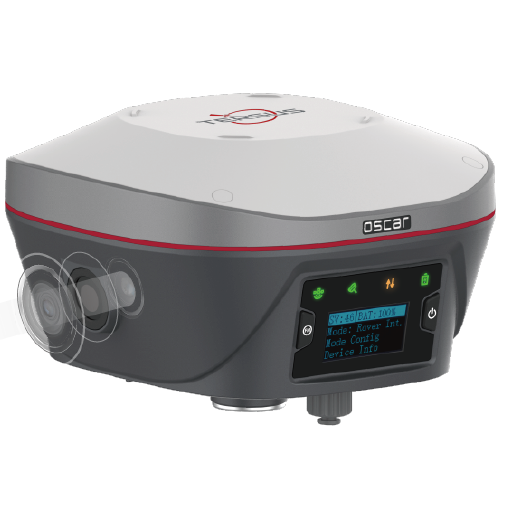
Tersus Oscar Trek
For Visual Positioning
Top Features:

Multi-Constellations & Frequencies

Centimeter-Level Accuracy

Unlimited Tilt Compensation

Integrated Camera

Connectivity
Transform Your Field Data into Rich, Visual Records
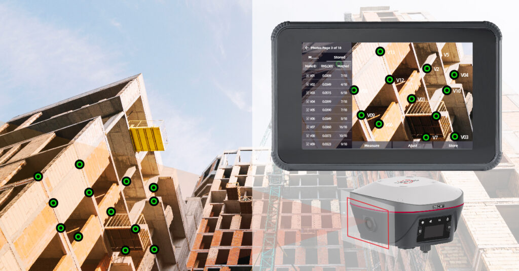
The Oscar Trek captures more than just coordinates—it documents the surrounding environment, visual details, and spatial relationships tied to each point. Its integrated camera and visual positioning workflow allow users to generate measurable points, validate site features, and create a traceable visual record. In short, it turns every point into a rich, visual record—not just a dot on a map.
Brings field context directly into the office.
Why Oscar Trek with Nuwa App stands apart.
The Oscar Trek isn’t just a GNSS receiver—it’s a visual positioning solution that bridges the gap between the field and the office. Key advantages include:
- Real-time data capture and validation — no cloud processing delays
- Fully offline operation — ideal for remote or secure locations
- Built-in visual verification — eliminates costly field revisits
- Measurable imagery and dense 3D point clouds (LAS) — for comprehensive documentation
- All-in-one performance — combines accuracy, speed, and situational awareness in a single device
Why Tersus?
The Oscar Trek is also a powerful, all-purpose GNSS receiver built for everyday fieldwork. It delivers flexibility, precision, and reliability across a wide range of workflows, from mapping to drone operations to surveying.

Dual Purpose: Visual or Traditional GNSS
The Oscar Trek delivers dense visual point capture and full GNSS functionality, operating with or without tilt as either a rover or base station for any mapping or surveying application.

Seamless Esri Integration
Integrates directly with ArcGIS Field Maps, Survey123, and other Esri field apps, bringing high-accuracy positioning into your GIS environment.

Drone Base Station Ready
Serve as a dependable base for drone missions, supporting both real-time RTK and post-processed (PPK) workflows.

TAP Real-Time Corrections
Access Tersus TAP global correction service for real-time accuracy, anywhere, anytime, without the need for a local base or radio link.
Technical Specifications
GNSS Tracking
576 channels supporting GPS, GLONASS, Galileo, BeiDou, QZSS, SBAS
Accuracy (RTK)
Horizontal: 1.5–2.0 cm RMS
Vertical: 2.5–3.0 cm RMS (typical)
Tilt Compensation
Calibration-free IMU, with no limit on angle. Tested RMS error of 3.7cm at a tilt angle of 110°
Connectivity
Cloud-based Caster Service included for broadcasting via NTRIP in the field.
Endurance
Dual hot-swappable batteries; up to 16 hours of continuous field operation.
Ruggedness
IP68 rating, 2 m drop resistance, full dust/water protection, operating range –40°C to +75°C
Form Factor
Compact smart antenna with an interactive OLED screen interface on the receiver.
Advanced Positioning
Supports Tersus Advanced Positioning (TAP) PPP Correction service for satellite-based real-time corrections down to CM precision.
Operating Modes
Configurable as rover, base, or static GNSS logger; supports real-time corrections via NTRIP, UHF radio, or PPP satellite corrections.
Visual Positioning
Built-in 2.3 MP camera, 120 fps image capture for photogrammetry, point measurement, and 3D reconstruction live in the field.
Any Questions?
Have any questions about the technical specifications?
Please get in touch with us for any inquiries you have!
NUWA + Visual Positioning with the Oscar Trek
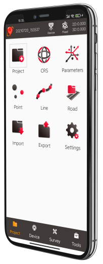
Tersus Nuwa software is a fully-featured, yet intuitive field data collection software designed for surveyors, engineers, drone pilots, and GIS professionals.
Nuwa software comes with every Tersus smart GNSS receiver purchase. Use it with a Tersus TC40 or TC80 Controller or Android device (Versions 6, 7, and later) with no annual fees.

World's Fastest Visual Surveying RTK

Simple Workflow
Pick, check, adjust, and save data easily, reducing time spent on fieldwork and data processing

Multi-Points At a Time
Pick many points in one image and measure, speeds up the entire process, helping you complete projects faster and more efficiently.

3D Modeling
NUWA Field Software
Watch how the Oscar Trek’s internal high-resolution camera, GNSS RTK, IMU tilt sensor, and the Tersus TAP PPP real-time solution work together to capture georeferenced photos while walking—no tripod or control points required. This video demonstrates the Nuwa App’s Quick Survey tool for capturing precise point measurements directly within project photos. It also highlights the Dense Point Cloud feature, which enables users to select areas within an image for high-resolution 3D modeling. The resulting point cloud can be exported and reviewed in the office using CloudCompare or other photogrammetry software.
FAQs
There’s no such thing as dumb questions, just frequently asked ones!
Whether you’re new to surveying technology or simply exploring the capabilities of our products, we’ve gathered a few of the most common questions to help you better understand how our systems work and what sets them apart.
When the Trek captures a point both visual positioning, how do I know what point it was later?
The NUWA software creates an image that is named the same as the point that was created. On that image it puts a red crosshair where the point was generated.
When the Trek creates a high-density point cloud, how do I get a LAS file from that to bring into my other software that I work with?
Once the point cloud or clouds have been generated, there is an export option on immediately generates an LAS file on the controller.
Do I need to do any post processing in an office software to get point clouds?
No. The processing is done on the controller in the field. No internet connection is required.
How far away can I measure points?
It’s recommended to be within 50’ to get good data. If you start going beyond those limits, the software will give you notifications that the data is not as accurate.
Can I load the images from the Visual Positioning capture into another software for post processing?
Yes. These can be loaded into other platforms for point clouds generation. Oftentimes this is added to drone data for a ground-based perspective.
Does it matter if the rod is level or how high the receiver is off the ground when capturing data?
No. The position is captured at the antenna, so the rod height is not important. It is also acceptable to aim the receiver upwards or downwards. If the subject you’re trying to capture is not at a horizontal perspective.
Does lighting affect data quality since this is photogrammetry? Yes. Doing a visual positioning capture into the sun, or with a highly shadowed area can yield lower density and less features to be extracted. There are scenarios when illuminating a trench or workspace can be helpful.
Can the Trek be used as more than a rover? Yes. The Trek can be a base, rover, network rover or a PPP rover.
Does the Oscar Trek support tilt compensation?
Yes. The Oscar Trek features calibration-free IMU-based tilt compensation, allowing you to measure points with up to 60° of pole tilt while maintaining centimeter accuracy.
How does visual positioning work?
Visual positioning uses the Oscar Trek’s built-in camera and AI-driven photogrammetry algorithms to determine 3D coordinates from captured images. This allows users to measure hard-to-reach or obstructed points, perform as-built documentation, and build point clouds in real time.
Can the Oscar Trek act as a base station?
Yes. Any Oscar Trek receiver can be configured as a base station and can broadcast corrections over UHF radio or NTRIP through a built-in SIM card slot and cloud-based caster service.
Is it compatible with third-party software?
Absolutely. The Oscar Trek works seamlessly with Tersus Nuwa, ESRI Field Maps, Survey123, and most third-party GIS and survey software that support NMEA or RTCM streams for GNSS Positioning, even when coupled with Tilt. However, the Camera and visual slam processing is proprietary to Nuwa software today.
What satellite constellations does it track?
The Oscar Trek is a full-constellation, multi-frequency receiver supporting GPS, GLONASS, Galileo, BeiDou, QZSS, and SBAS.
What makes the Oscar Trek different from other GNSS receivers?
The Oscar Trek combines traditional RTK GNSS accuracy with advanced vision-based measurement technology. Users can capture georeferenced photos, extract points directly from images, and even generate point clouds in the field without extra software — dramatically improving field-to-office efficiency
Built In-House by Tersus.
Built to Perform for You.
At Tersus, building “just another RTK system” is never the goal. Tersus designs and develops its own GNSS boards and core RTK technologies, building solutions from the ground up rather than relying on generic, off-the-shelf components. It’s a simple belief that guides every receiver we’ve built: build better, or don’t build at all. Every receiver delivers high-performance, centimeter-level RTK accuracy without unnecessary cost, providing reliability and precision in even the toughest environments.