Ultra-Compact
LUKA is a palm-sized, full-featured IMU-GNSS receiver and meets the demand of centimeter precision positioning in challenging environments.
From land surveyors and GIS experts to utilities personnel and drone mapping specialists, the Luka is built to thrive in any environment. This lightweight marvel provides continuous, all-day operation and incredible versatility.
For Visual Surveying
The Tersus premier RTK smart GNSS receiver combines a high-definition camera, IMU tilt compensation, and GNSS for seamless, non-contact measurements.
It processes images in real-time to instantly provide precise coordinates, streamlining project completion. It is compatible with leading 3D modeling software and utilizes raw data for accurate, flexible post-processing in creating detailed 3D models.
Without Integrated Camera
Equipped with an advanced multi-constellation and multi-frequency GNSS board, the Oscar Ultimate GNSS receiver ensures exceptional accuracy and consistent signal detection.
Note that it lacks the integrated high-definition camera for visual surveying that’s included in Oscar Trek.
Affordable, Professional GNSS
The David30 receiver sensor offers exceptional versatility, making it a perfect GNSS solution for numerous specialized applications. It seamlessly integrates with Tersus GeoCaster for NTRIP corrections and serves as a dedicated base station.
Additionally, it excels as a GNSS sensor for mobile mapping, machine control, precision agriculture, and UAV systems applications needing real-time corrections.
Powerful platform for data collection
The TC80 is an ultra-lightweight handheld for surveying and mapping applications, weighing only 320 g and measuring just 1.96 cm thick. This controller is designed ergonomically, considering its optimized usage in the field. Its grip is designed to be held with one hand, making it easy to operate.
The Tersus TC40 Controller is a rugged, easy-to-use field device built for demanding survey work. Its 8-inch touchscreen delivers clear visibility outdoors, while a powerful octa-core processor and Android operating system ensure smooth performance with Tersus Survey software.
A removable high-capacity battery provides up to 10 hours of continuous use, keeping crews productive all day. Designed with durability in mind, the TC40 features a protective housing and IP67 rating, making it reliable in harsh field conditions.
Bathymetric Surveying
TheDuck™ is an autonomous surface vessel designed for bathymetric surveys of aquatic environments like rivers, lakes, reservoirs, and coastal areas. It features an optional single-beam echo sounder and offers remote-controlled real-time display capabilities, allowing for control from over a mile away.
Fly Light. Map Right. Aerial or Mobile Applications
The MVP 100 delivers survey-grade results with typical point cloud accuracy of 3–5 cm using PPK, supported by high-precision LiDAR measurements. Its triple-return capability and long detection range enable reliable ground extraction even in dense vegetation and complex terrain.
Handheld SLAM Scanner
An AI-driven RTK-SLAM engine combines LiDAR, vision, and GNSS data to deliver accurate, reliable positioning even in complex environments.
Handheld or Backpack SLAM Scanning
TheTersus MVP S2 is a professional-grade mobile 3D SLAM scanner that delivers sub-3 cm absolute accuracy using advanced RTK-SLAM technology.
The system includes a high-precision LiDAR, panoramic camera with a 1-inch Sony sensor and Leica lens, dual hot-swappable batteries (up to 3 hours of uninterrupted data collection per set), and full processing software.
CORS Network Software for Reliable, Scalable RTK Services
Tersus Precision NetWork (PNW) RTK System Management and Positioning Services Software powers everything from a handful of reference stations to full regional CORS networks, delivering fast, reliable, centimeter-level positioning to thousands of users at once.
Tersus Advanced Position (TAP)
TAP delivers global Precise Point Positioning (PPP) with accuracy of 1.5 cm horizontally and 3 cm vertically. Works seamlessly with Tersus smart GNSS receivers.
Available in one, two, and three-year subscription plans.
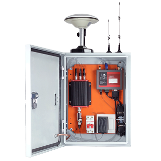
RTK Permanent Mounted Base Station Kit
The Tersus GeoBee is an affordable permanent reference station, for transmitting or receiving NTRIP corrections.
When combined with Tersus NTRIP Caster Service, NTRIP Modem, and David30 GNSS Receiver, the GeoBee enables users to easily send Real Time Kinematic (RTK) corrections via Ethernet, 2G/3G/4G connections using just a SIM card, or Ethernet cable, without requiring a static IP.
The NTRIP caster service supports multiple bases simultaneously.
Your All-In-One Solution
Nuwa is a field survey app designed for Tersus controllers or other Android devices that works seamlessly with Tersus Smart GNSS receivers.
It features a graphical interface with a background map for CAD stakeout, road stakeout, Earthwork, tilt survey, and COGO tools for area perimeter, azimuth distance, and grid to ground calculations.
Powered by Esri
Connect people, locations, and data using interactive maps. Work with smart, data-driven styles and intuitive analysis tools. Share your insights with the world or specific groups.